


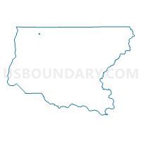
Port Voting District, King County, Washington
About
Outline

Summary
| Unique Area Identifier | 685481 |
| Name | Port Voting District |
| County | King County |
| State | Washington |
| Area (square miles) | 0.14 |
| Land Area (square miles) | 0.14 |
| Water Area (square miles) | 0.00 |
| % of Land Area | 100.00 |
| % of Water Area | 0.00 |
| Latitude of the Internal Point | 47.72379220 |
| Longtitude of the Internal Point | -122.16967720 |
Maps


Graphs
Select a template below for downloading or customizing gragh for Port Voting District, King County, Washington


Neighbors
Neighoring Voting District (by Name) Neighboring Voting District on the Map
- Chateau Voting District, King County, WA
- Firlock Voting District, King County, WA
- Kamiakin Voting District, King County, WA
- Rexgate Voting District, King County, WA
- Violet Voting District, King County, WA